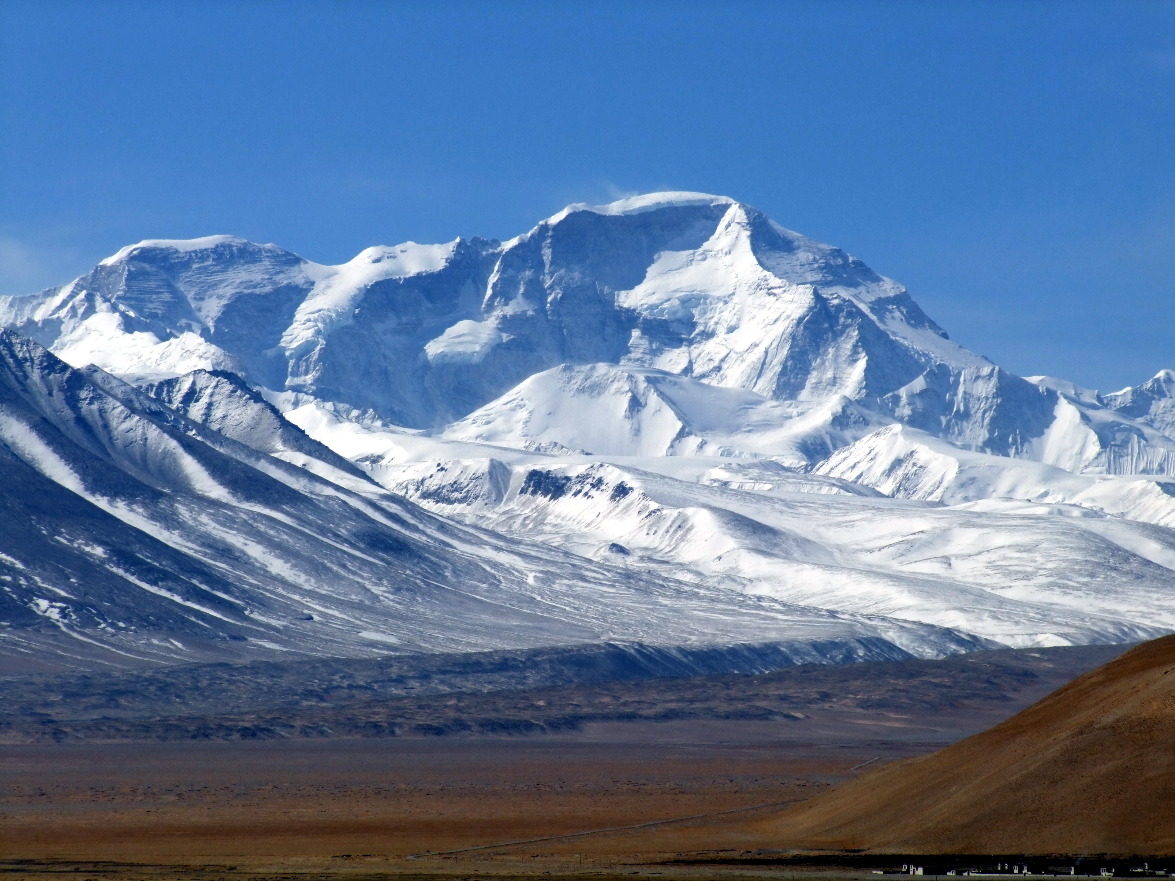
Fifty million years of tectonic fury, raised into the sky. The mountains that ended empires, broke expeditions, and became the closest thing humanity has to a god written in stone.
The Himalayas are not just mountains. They are the visible scar of two continents colliding in slow motion — a crash that began 50 million years ago when the Indian plate slammed into Eurasia at four centimetres a year. The impact crumpled the earth's crust skyward, raising ancient seabeds into the stratosphere. Marine fossils have been found near Everest's summit. The limestone underfoot was once the floor of the Tethys Sea.
The range stretches 2,400 kilometres across five nations, containing all fourteen peaks above 8,000 metres — the Death Zone, where the human body begins to die faster than it can recover. No supplemental oxygen, no acclimatisation regimen, no amount of willpower fully defeats this physics. The mountains simply do not care.
Yet the Himalayas are profoundly alive in every other sense. They feed the Ganges, the Indus, the Brahmaputra, the Mekong, the Yangtze. They spawn monsoons, block arctic winds, create the climate conditions that support a third of humanity. To Hindus, they are the throne of Shiva. To Buddhists, the mandala of the universe. To the Sherpa, they are home.
Before it was "Everest," it had names far older and more meaningful. Tibetans called it Chomolungma — Goddess Mother of the World. Nepalis named it Sagarmāthā — Peak of Heaven. It received its English name in 1865 after Sir George Everest, who ironically objected: his name couldn't be written in Hindi, and he argued the mountain should keep its local name. Colonial bureaucracy overruled him.
George Mallory, who famously said he climbed "because it's there," vanished near the summit in 1924 alongside Andrew Irvine. His body was found in 1999, preserved by ice at 8,155m — but whether he reached the summit before dying remains unknown. His camera, which might hold the answer, has never been found.
"We knocked the bastard off."— Edmund Hillary, 1953
Modern Everest is a commercial operation. Guided expeditions cost $30,000–$100,000. The 2019 photograph of a queue of climbers waiting in the Death Zone went viral globally. In 2023, over 600 people summited — a new record. The mountain is slowly becoming the world's most expensive and crowded outdoor adventure, while its glaciers retreat and its flanks accumulate tons of discarded equipment.
Nepal–Tibet border, Mahalangur Himal sub-range. Coordinates: 27.9881°N, 86.9250°E. Straddles the Sagarmatha Zone (Nepal) and Tingri County (Tibet).
The highest point visible from the Khumbu valley. From Kala Patthar (5,644m), Everest rises as a dark pyramid above the Lhotse–Nuptse wall. A distinctive wind-blown snow plume often trails from the summit. Visible from aircraft on Kathmandu–Lhasa routes on clear days.
Look for the distinctive black rock pyramid shape rising above a massive white wall (Nuptse). The summit is often marked by a horizontal snow plume blown by the jet stream. From the north (Tibet), it appears as a broader, lighter-colored pyramid. It is always the highest point on the horizon from any direction.
Nepal side: Fly Kathmandu → Lukla (35 min), then 8–10 day trek via Namche Bazaar (3,440m) and Gorak Shep to Base Camp (5,364m). Tibet side: Drive from Lhasa via Shigatse and Tingri to Rongbuk Monastery — the highest monastery in the world — and then to Chinese Base Camp (5,200m). Permits required from both sides.
In 1856, surveyor T.G. Montgomerie spotted the peak from 200 km away and labelled it "K2" — the second Karakoram peak measured. Most survey names were replaced by local names. K2 was so remote that no single local name was widely known, so the utilitarian number stuck. It's the only major peak in the world still known by its survey designation.
Every route on K2 is brutally technical. The standard Abruzzi Spur culminates in the Bottleneck — a narrow couloir directly beneath a massive serac. On August 1, 2008, that serac fell, destroying fixed ropes and stranding eleven climbers above. All eleven died. It remains the worst single disaster in K2's history.
"K2 is the mountaineer's mountain — it doesn't let you off easy."— Reinhold Messner
K2 was the final eight-thousander unclimbed in winter. On January 16, 2021, ten Nepali climbers summited together in -60°C wind. Nirmal "Nims" Purja led the team, and they paused just below the summit to sing the Nepali national anthem before the final steps.

Pakistan–China border, Central Karakoram. 35.8825°N, 76.5133°E. Sits at the head of the Baltoro Glacier in Gilgit-Baltistan, Pakistan.
Visible as a near-perfect pyramid from Concordia — the junction of the Baltoro and Godwin-Austen glaciers. It towers above all surrounding peaks. Not visible from any road or city; you must trek in.
A steep, symmetrical triangular pyramid — steeper and more compact than Everest. The Abruzzi Spur (SE ridge) and the Bottleneck couloir are visible from the south. Rock is dark granite banded with lighter streaks. Almost always has snow blowing from upper ridges.
Fly to Skardu (Pakistan), jeep to Askole village (3,000m). Then a 7-day trek through the Baltoro Glacier — one of the world's longest non-polar glaciers — to K2 Base Camp at Concordia (5,150m). Total approach: ~12 days. No helicopter access. Permits via Alpine Club of Pakistan.
Kangchenjunga is not one mountain but five — a vast massif with five distinct summits, each representing a treasure: gold, silver, gems, grain, and holy scriptures. For centuries it was believed to be the world's highest. The Sikkimese consider it their guardian deity.
In 1955, leader Charles Evans pledged to Sikkim: no climber would tread on the sacred summit. Joe Brown and George Band stopped just below the highest point. This tradition has been honoured by virtually every subsequent team. In a sport defined by ego, Kangchenjunga represents something rarer: deference.
Nepal–Sikkim (India) border. 27.7025°N, 88.1475°E. The easternmost eight-thousander, straddling the Taplejung District (Nepal) and Sikkim state (India).
Dominates the skyline from Darjeeling and Pelling in India — no trekking needed. On clear mornings from Darjeeling's Tiger Hill, the entire five-peaked massif glows orange at sunrise. Easily the widest eight-thousander on the horizon.
Unmistakable: a wide, multi-peaked wall rather than a single summit. Five distinct peaks spread across a 20km ridge. Much broader and more massive than any other Himalayan peak. From the south (Nepal), the main summit is the leftmost high point.
Viewing: Fly to Bagdogra, drive to Darjeeling or Pelling — both offer spectacular views by road. Base Camp: Fly to Bhadrapur (Nepal), drive to Taplejung, then 10–12 day trek to Base Camp. India side: Restricted; requires special permits through Gangtok, Sikkim.
Lhotse — the world's fourth-highest mountain — lives in perpetual anonymity. The two peaks share the South Col; Everest climbers literally walk past Lhotse's flanks without a second glance. Yet Lhotse has one of the most intimidating features in the Himalayas: its south face, a 3,000-metre wall of rock and ice.
Lhotse's south face was climbed only once, in 1990, by a Soviet team — and is one of the rarest routes in high-altitude mountaineering. The face is so steep and avalanche-prone that most attempts have ended in retreat or tragedy. Jerzy Kukuczka, the second person to summit all 14 eight-thousanders, fell to his death on this face in 1989.
Many climbers who summit Everest add Lhotse to their record by traversing from the South Col — but it requires descending significantly and re-ascending, turning an already extreme day into a superhuman effort. Denis Urubko did it solo, without supplemental oxygen, in 2010.
Nepal–Tibet border, 27.9617°N, 86.9333°E. Just 3km south of Everest, connected via the South Col at 7,906m. Part of the same massif.
From the Khumbu valley, Lhotse forms the massive wall directly south of Everest. From Kala Patthar viewpoint, it's the enormous face to the right. From the Tibetan side, it appears as a subsidiary peak behind Everest.
The defining feature is the south face — an enormous, steep wall of dark rock and ice. From the south, it's a broad, flat-topped summit connected to Everest by a high ridge. Often mistaken for Everest itself from certain angles.
Same approach as Everest: fly to Lukla, trek to Everest Base Camp (8–10 days). Lhotse shares base camp facilities with Everest. The climbing route follows the Everest route to Camp 3 at the Lhotse Face before diverging at the Yellow Band.
Many mountaineers consider Makalu the most beautiful eight-thousander — a near-perfect four-sided pyramid that rises 19 km southeast of Everest. Its isolated position makes it one of the most visually stunning mountains on Earth, visible as a dark, symmetrical peak from dozens of vantage points across the Khumbu region.
Makalu's first ascent in 1955 by a French expedition led by Jean Franco was a masterpiece of planning: all nine summit team members reached the top over two days. In an era of heroic, often tragic expeditions, this was a clinic in efficiency. The success rate today remains below 30%, making it one of the most demanding eight-thousanders.
Climbers describe Makalu as psychologically punishing. Its long, exposed approach ridges offer no shelter, and the final summit pyramid involves sustained technical climbing at extreme altitude. The mountain is known for sudden, violent weather changes that can strand climbers above 8,000m without warning.
Nepal–Tibet border, 27.8892°N, 87.0889°E. 19km southeast of Everest, in the Makalu-Barun National Park — one of Nepal's most pristine wilderness areas.
Visible from Everest Base Camp as a dark pyramid to the southeast. From Kala Patthar viewpoint, it's the prominent peak to the far right of the panorama. Also visible from aircraft on Kathmandu–Lukla flights.
A near-perfect four-sided pyramid with four prominent ridges. Darker rock than its neighbors. Isolated — no other major peaks crowd it. The summit pyramid is a distinctive steep triangle visible from all sides.
Fly to Tumlingtar (eastern Nepal), then trek through the Makalu-Barun valley for 10–12 days to Base Camp (5,650m). Alternatively, approach from the Khumbu side via the Arun valley. One of the most remote and least-visited trekking regions in Nepal. No teahouses — camping only.
Cho Oyu — the Turquoise Goddess — is considered the "friendliest" eight-thousander. Its standard northwest face route from Tibet involves mostly moderate snow climbing, and its fatality rate is the lowest among the 8,000m peaks. It has become the mountain of choice for climbers building their CV before tackling harder peaks like Everest or K2.
In 2006, Cho Oyu's slopes witnessed tragedy of a different kind: Chinese border guards shot Tibetan refugees crossing the nearby Nangpa La pass, killing a 17-year-old nun named Kelsang Namtso. The incident, captured on video by mountaineers, went viral and briefly exposed the human cost of the region's geopolitics.
Despite its gentler reputation, Cho Oyu is still over 8,000m. Altitude sickness, crevasses, and unpredictable weather claim lives every season. The mountain teaches humility to those who underestimate it — several experienced climbers have died here after treating it as "easy."

Nepal–Tibet border, 28.0942°N, 86.6608°E. 20km west of Everest, on the Nangpa La — the main Sherpa trade route between Nepal and Tibet.
Best seen from the Gokyo valley (Nepal side) — it dominates the northern horizon beyond the Gokyo lakes. From Gokyo Ri viewpoint, it appears as a broad, massive peak to the northwest. Also visible from Renjo La pass.
Broad and massive rather than sharp. A turquoise-blue ice wall on the southwest face is distinctive. Less dramatic than neighbors but noticeably wider. From Tibet, a long, moderate snow slope leads to the summit — the gentle profile that earned its "easy" reputation.
Viewing: Trek the Gokyo Lakes trail from Lukla (branch off the Everest trail at Namche). Climbing: Usually approached from Tibet via Lhasa–Tingri road, then drive to Chinese Base Camp. Nepal approach via Gokyo adds 3–4 days. Climbing permits ~$10,000.
Declared the world's highest mountain in 1808 — a title it held for 30 years. Dhaulagiri rises over 7,000m above the Kali Gandaki gorge to its east, one of the world's deepest valleys. The sheer relief — from subtropical river valley to icy summit — is staggering and unique in the Himalaya.
Dhaulagiri's south face is a 4,000-metre wall that has repelled almost every attempt. Slovenian climber Tomaž Humar's 2004 solo attempt on this face — spent alone for days at extreme altitude before helicopter rescue — is one of mountaineering's most audacious and debated feats.
The first ascent in 1960 by a Swiss-Austrian team was remarkable for its approach: they flew a small aircraft — a Pilatus Porter — directly to the Northeast Col at 5,700m, making it the first eight-thousander expedition to use airplane logistics. The plane crashed on the glacier but all survived.
Central Nepal, 28.6967°N, 83.4875°E. Entirely within Nepal. Rises above the Kali Gandaki valley — the deepest gorge on Earth when measured from the flanking summits of Dhaulagiri and Annapurna.
Spectacularly visible from Poon Hill (3,210m) on the Annapurna Circuit — one of Nepal's most popular viewpoints. Also visible from Pokhara on clear days as the massive white peak to the northwest. From Muktinath, it towers to the west.
Massive and heavily glaciated — the "White Mountain" is aptly named. Distinguished by its enormous south face (4,000m vertical wall) and its isolated position. Far whiter than most peaks due to extensive snow and ice coverage. A distinctive summit ridge runs east-west.
Viewing: Trek to Poon Hill from Pokhara (3–4 days). Or walk the Annapurna Circuit to Jomsom/Muktinath. Base Camp: Fly to Pokhara, drive to Beni, trek via the Myagdi River valley and French Pass (5,360m) to Base Camp — 10–12 days. One of the most demanding approach treks in Nepal.
Manaslu is Japan's Himalayan obsession. Three expeditions, four years, a tragic avalanche that killed 18 villagers in the nearby Sama village, and Buddhist monks called in to appease the mountain spirits — before finally, on May 9, 1956, Toshio Imanishi and Gyalzen Norbu reached the summit. The mountain became a symbol of Japanese post-war ambition and perseverance.
In the 2020s, Manaslu has become "the new Everest" — a more affordable, less crowded alternative for guided eight-thousander expeditions. Permits cost a fraction of Everest's, and the standard route from the northeast is technically moderate. But the mountain punishes complacency: a massive avalanche in 2012 killed 11 people on the popular standard route.
The Manaslu Circuit trek — 177km around the mountain — is widely considered one of the finest long-distance treks in Nepal. It crosses the Larkya La pass at 5,160m and passes through remote Tibetan-influenced villages. In many ways, it's what the Annapurna Circuit was 30 years ago, before commercialisation.
Central Nepal, Mansiri Himal, 28.5497°N, 84.5597°E. Entirely within Nepal's Gorkha District. About 64km east of Annapurna.
Best seen from the village of Samagaun (3,530m) on the Manaslu Circuit trek. Not easily visible from major cities. From the Kathmandu–Pokhara highway, it occasionally appears as a distant white dome on very clear days.
A large, dome-shaped peak — less dramatic than many eight-thousanders but more massive. The summit is rounded rather than pointed. Often shrouded in cloud. Distinguished by its broad north face and long, sweeping ridges rather than dramatic spires.
Circuit Trek: Drive from Kathmandu to Soti Khola (8 hrs), then 12–14 day circuit around the mountain via Larkya La (5,160m). Base Camp: From Samagaun village on the circuit, a 2-day side trip reaches Base Camp at 4,800m. Restricted area — requires permits and a guide (minimum 2-person groups).
Nanga Parbat consumed 31 lives before Hermann Buhl stood on its summit in 1953 — a solo ascent of 40 hours above 8,000m, surviving a night standing on a ledge, leaning on a ski pole. A Nazi-sponsored campaign of the 1930s, a 1937 avalanche that killed all 16 people in Camp IV overnight, a 1934 disaster that killed 9. The mountain earned every syllable of its name.
On July 3, 1953, Hermann Buhl left his last camp at 7,800m for a solo summit push. He reached the top at 7 PM — far too late. With no bivouac equipment, he spent the night standing on a narrow ledge at 8,000m, hallucinating and swaying in the wind, kept alive by Pervitin (amphetamine) and willpower alone. He descended the next morning, frostbitten but alive. No climber has replicated this feat.
The Rupal Face is the tallest mountain face on Earth — 4,600 metres of near-vertical rock and ice. Reinhold Messner and his brother Günther climbed it in 1970; Günther died during the descent on the other side. Reinhold's account of what happened has been disputed for decades, splitting the mountaineering world.
Western Himalaya, Pakistan. 35.2375°N, 74.5892°E. Entirely within Pakistan's Gilgit-Baltistan territory. The westernmost eight-thousander — marks the Himalaya's western anchor.
Visible from the Karakoram Highway (KKH) near Chilas. The enormous Rakhiot face rises directly above the Indus valley. From Fairy Meadows (3,300m), the full Rupal Face is visible — an overwhelming 4,600m wall filling the sky. Also visible from some Islamabad–Gilgit flights.
The Rupal Face is unmistakable — the tallest mountain face on Earth. From the south, it's an immense wall with hanging glaciers. From Fairy Meadows (north), multiple hanging glaciers cascade down enormous rock buttresses. The summit is often cloud-capped. Much more massive-looking than photographs suggest.
Fairy Meadows (best viewpoint): Fly Islamabad → Gilgit (1 hr) or drive KKH (15 hrs) to Raikot Bridge, then jeep to Tato village, and 3-hour hike to Fairy Meadows. Rupal valley: Drive from Chilas to Tarashing, trek 2 days to Rupal Base Camp. Warning: The KKH jeep track to Fairy Meadows is one of the world's most dangerous roads.
On June 3, 1950, Maurice Herzog and Louis Lachenal stood on the summit of Annapurna and crossed a threshold no human had before — 8,000 metres. The first eight-thousander ever climbed. They descended in a storm that cost both men their fingers and toes. Herzog's memoir, simply titled "Annapurna," ends with one of mountaineering's most famous lines: "There are other Annapurnas in the lives of men."
Chris Bonington's 1970 British expedition climbed Annapurna's south face — a 3,000m wall of ice and rock that changed Himalayan mountaineering forever. Dougal Haston and Don Whillans reached the summit, but Ian Clough was killed by an ice avalanche during the descent. The route was the first great Himalayan "big wall" climb.
For every three summits of Annapurna, roughly one person dies. The mountain's ~32% fatality rate is the highest among the fourteen eight-thousanders. Massive avalanches sweep the south face regularly. In 2014, a blizzard killed 43 trekkers on the Annapurna Circuit — the deadliest trekking disaster in Nepal's history.
"There are other Annapurnas in the lives of men."— Maurice Herzog, Annapurna (1951)
Central Nepal, 28.5961°N, 83.8203°E. Part of a 55km massif with multiple peaks. Just 30km north of Pokhara — the closest eight-thousander to any major city.
Visible directly from Pokhara's lakeside on clear mornings — one of the world's great urban mountain views. From Poon Hill, both Annapurna I and the full massif are visible. From Annapurna Base Camp (4,130m), the south face fills the entire sky.
The south face is the key identifier — a massive 3,000m wall of rock and ice, wider than it is tall. The summit ridge is broad and often corniced. From Pokhara, Annapurna I is partially hidden behind lower Annapurna peaks (II, III, IV, South). The massif as a whole is enormous — wider than any other in the range.
ABC Trek: Fly to Pokhara (30 min from KTM), then 7–10 day Annapurna Base Camp trek via Ghandruk and Chomrong. Annapurna Circuit: 12–21 day trek around the entire massif, crossing Thorong La (5,416m). Easy view: Poon Hill trek from Pokhara (3–4 days). No climbing permits needed for treks — standard ACAP permit ($30).
Ama Dablam is not an eight-thousander, but it is arguably the most visually arresting peak in the entire Himalayan range. Its name means "Mother's Necklace" — the hanging glacier near the summit forms the pendant. From the Khumbu valley below, the mountain rises in a near-perfect twin-pointed spire that has graced thousands of photographs.
Technically far more demanding than many peaks twice its height. The standard southwest ridge involves multi-pitch rock climbing, sustained ice, and exposed traverses above 6,000m. It's the finest alpine-style climb in Nepal — where difficulty is matched by being surrounded by the greatest mountain landscape on Earth.
In 2006, a section of the hanging glacier broke loose and destroyed several camps, killing climbers. The mountain is a reminder that beauty and danger are not opposites in the Himalaya — they are the same thing.
Nepal, Khumbu region. 27.8614°N, 86.8611°E. Sits in the heart of the Everest trekking region, directly visible from the main trail between Namche Bazaar and Everest Base Camp.
One of the first major peaks you see trekking from Namche Bazaar toward Everest. Appears as a stunning sharp spire to the south-southeast. Impossible to miss — it dominates the valley from Tengboche monastery onward. Visible from virtually every viewpoint on the EBC trek.
Unmistakable: a sharp, steep spire with two distinct points and a hanging glacier ("the pendant") between the summit and the lower shoulder. Looks like a dagger from most angles. No other peak in the Khumbu has this profile. The southwest ridge forms a dramatic rising line visible from below.
Viewing: On the Everest Base Camp trek — fly Lukla, trek 3–4 days to Tengboche for front-row views. Base Camp: From Pangboche village (3,930m), a half-day hike to BC at 4,570m. Climbing: Permits ~$400 per person, plus icefall doctor fees. Most commercially guided of Nepal's technical peaks. Allow 18–20 days for a summit attempt.
Shishapangma is the fourteenth and final eight-thousander — the one most climbers forget. Entirely within Tibet, it was closed to the outside world until 1964, making it the last eight-thousander climbed, by a Chinese expedition of 10 who summited en masse on May 2.
In 1999, an avalanche on the south face killed Alex Lowe — one of the greatest American alpinists — and David Bridges. The glacier consumed their bodies and returned them 17 years later, in 2016, as the ice retreated. The mountain had kept them for nearly two decades.
Tibet (China), 28.3525°N, 85.7797°E. The only eight-thousander entirely within one country (China/Tibet). Part of the Jugal Himal sub-range, about 120km NW of Kathmandu.
Visible from the Friendship Highway between Kathmandu and Lhasa — look north from the highway near Nyalam. From Cho Oyu base camp (in Tibet), Shishapangma is visible to the east. Occasionally visible from Kathmandu valley on exceptionally clear days.
A long, flat summit ridge — less dramatic than other eight-thousanders. Three sub-summits along a broad crest. Often cloud-covered. The north face is a moderate snow slope; the south face is steeper and more technical. Looks "gentler" than most peers.
Via Lhasa or Kathmandu to Nyalam (Tibet), then drive to base camp. Requires Chinese visa + Tibet Travel Permit + Alien Travel Permit + Military Permit. Usually arranged through Lhasa-based agencies. Alternatively visible from Nepal's Langtang trek region (across the border). One of the most bureaucratically challenging eight-thousanders to access.
Gangkhar Puensum holds a distinction unlike any other: at 7,570 metres, it is the highest peak in the world that has never been climbed. It sits in Bhutan's remote Lunana district, surrounded by glaciers and accessible only via multi-week approach. Four expeditions attempted it in the 1980s; all failed.
In 1994, Bhutan banned all mountaineering above 6,000 metres — citing respect for local spirits that inhabit the high peaks. Bhutanese culture regards summits as homes of deities. Gangkhar Puensum has been legally off-limits ever since. It may remain unclimbed forever — not because of physical impossibility but because a small kingdom decided its gods deserved privacy.
In a world where every summit is a commercial objective, Bhutan's position is almost radical in its restraint.
Bhutan, 28.0333°N, 90.4533°E. Remote Lunana district in northern Bhutan, near the Tibet border. One of the most isolated peaks in the Greater Himalaya.
Visible from Dochula Pass (3,100m) near Thimphu on clear days — a distant white peak on the northern horizon. Also visible from the Bumthang valley. Very rarely photographed due to remoteness. Often obscured by clouds.
A heavily glaciated peak with multiple sub-summits. Appears as a broad, white massif rather than a sharp spire. Rarely seen without cloud cover. Distinguished mainly by its remoteness — if you're looking at a large glaciated peak from central Bhutan, this is likely it.
Viewing: Fly to Paro (Bhutan), drive to Dochula Pass (2 hrs from Thimphu) for distant views. Closer: The Snowman Trek (25–30 days, one of the world's hardest treks) passes through Lunana and offers closer views. Important: Bhutan requires a minimum $100/day tourist tariff. Climbing is permanently banned above 6,000m. No exceptions.
In 1957, Jimmy Roberts' expedition came within 50 metres of Machapuchare's summit — and turned back. Not because they couldn't continue, but out of deference to a promise made to the Nepalese government. Seven years later, Nepal closed the mountain entirely. It has been off-limits ever since. The Nepalese consider it the abode of Shiva, and no human footprint has ever marked its top.
Machapuchare's twin-pointed "fish tail" profile dominates the view from Pokhara. From the Annapurna base camp trail, it frames every photograph. Millions have seen this mountain; none have stood on it.
There is a story that the mountain bleeds — snowmelt running through iron-rich minerals turns certain gullies a deep russet-red in spring. The local people have always known this as the god marking his territory.
Nepal, Annapurna Himal. 28.6308°N, 83.9478°E. Part of the Annapurna massif, just 25km north of Pokhara — Nepal's second-largest city.
Dominates the Pokhara skyline — visible from every rooftop and lakeside restaurant in the city. No trekking needed. For closer views, trek the Annapurna Base Camp trail or the newer Mardi Himal trail. Visible on clear days from Kathmandu–Pokhara flights.
Absolutely unmistakable: a sharp, steep spire with a twin-pointed summit shaped like a fish tail. From Pokhara, the two points are visible; from other angles, only one point shows. The steepest-looking peak in the Annapurna region. Much sharper and more dramatic than neighboring peaks.
City view: Fly to Pokhara (30 min from KTM) — visible from the airport. Close-up: Mardi Himal trek (5–7 days) takes you to the mountain's base. ABC trek (7–10 days) passes directly beneath its south face. Sunrise: Sarangkot viewpoint above Pokhara (30 min drive + short hike) for the famous dawn silhouette. Climbing is permanently and unconditionally banned.
To Hindus, Kailash is the home of Shiva. To Tibetan Buddhists, the dwelling of Demchok. To Jains, Ashtapada — where their first teacher attained liberation. To Bon followers, the seat of all spiritual power. Four religions, one mountain, zero climbers. Not because it's inaccessible — technically, it could be climbed — but because no one with knowledge of its sacred status has been willing to try.
The 52-kilometre Kora circuit, at altitudes reaching 5,700m, is one of the holiest pilgrimages in the world. Tibetan Buddhists believe completing 108 circuits leads to nirvana. Some pilgrims perform the entire Kora as prostrations — lying flat and measuring progress body-length by body-length. This takes three weeks.
Reinhold Messner was reportedly offered a permit to climb Kailash. He declined: "If we conquer this mountain, then we conquer something in people's souls." Some mountains are more powerful unclimbed.
"If we conquer this mountain, then we conquer something in people's souls."— Reinhold Messner (attr.)
Western Tibet, China. 31.0672°N, 81.3119°E. Remote — over 1,200km from Lhasa, 900km from Kathmandu. Near the source of four of Asia's greatest rivers: the Indus, Sutlej, Brahmaputra, and Karnali.
Stands alone in the western Tibetan plateau — no neighboring peaks of similar height. Visible from 100km+ on clear days as an isolated dome/pyramid rising from the flat plateau. Lake Manasarovar (4,590m) at its base provides the iconic reflection photograph.
A near-perfect dome shape with distinctive horizontal rock striations and a prominent vertical gash on the south face. Darker and more dome-shaped than typical Himalayan peaks. Snow-covered but not heavily glaciated. Its symmetry and isolation make it look almost artificial — a quality that feeds the mythology.
From Tibet: Fly to Lhasa, then 3-day overland drive west via Saga and Paryang to Darchen (4,575m) — the Kora starting point. From Nepal: Fly to Simikot (far western Nepal), trek to Hilsa border crossing, enter Tibet. From India: Via the Lipulekh Pass (seasonal, political tensions). The Kora circuit takes 1–3 days walking. All routes require Chinese visa + Tibet permits + military permits. Altitude acclimatisation critical — Darchen is already at 4,575m.
All 15 peaks featured on this page, scaled proportionally. The red dashed line marks the Death Zone — above 8,000m, the human body begins to shut down.
The Abominable Snowman is embedded in Himalayan culture. Multiple expeditions found unexplained footprints. Hillary mounted a dedicated search. Science has yet to prove its existence. The Sherpa have always known where it lives: in the space between what is seen and what is believed.
George Mallory vanished near Everest's summit in 1924. His body was found 75 years later — but the mystery deepened. His goggles were in his pocket, suggesting a night descent. His camera has never been found. Some climbers claim to feel a presence near the Northeast Ridge in good weather.
Hidden in the Himalayas — according to Tibetan tradition — lies Shambhala, a mythical kingdom of enlightened beings. James Hilton romanticised this as "Shangri-La." Multiple expeditions searched. Several explorers claimed to have approached it without entering. The mountains gave nothing away.
Near Everest's summit — at nearly 9,000m — there is limestone containing fossils of marine creatures: trilobites, brachiopods, crinoids. Remnants of creatures from the Tethys Ocean 450 million years ago, now the highest rocks on Earth. Geology is the longest story ever told.
Before 1953, 31 climbers had died on Nanga Parbat. The 1937 avalanche killed all 16 in Camp IV. Local people said the mountain fed on German ambition and returned nothing. Curse or statistics — for every 2 summits, roughly 1 death. The Naked Mountain did not negotiate.
Lord Shiva's trident rests on Kailash's summit. The Indus, Sutlej, Brahmaputra, and Karnali all originate near Kailash, flowing in four directions as if the mountain is the literal source of the world. The myth and the hydrology converge — a billion people depend on these rivers.
A white lion with a turquoise mane, dwelling in high glaciers — guardian of the mountains. It appears on the Tibetan flag, on monastery walls. Some say those who survived altitude sickness glimpsed it in hallucination. Above 8,000m, the boundary between metaphor and experience dissolves.
Tibetan texts describe "beyul" — sacred sanctuaries hidden in Himalayan folds, accessible only in catastrophe. Pemako, in the Tsangpo gorges, is the most celebrated. Botanist Frank Kingdon-Ward found extraordinary biodiversity there. Whether beyul or not, the place is genuinely extraordinary.
At sunrise and sunset, high peaks flush salmon-crimson. Sherpa tradition says this is the mountain breathing. To see it before a climb is a blessing. To see blood-red rather than golden is an omen of storm. Every culture in the Himalaya's shadow has built a vocabulary around the mountains' moods.
Not simply guides — the genetic inheritors of altitude. They carry the EPAS1 gene variant for efficient oxygen metabolism. Ang Rita summited Everest 10 times without supplemental oxygen. Kami Rita has summited 29 times. The greatest high-altitude climbers on Earth are, by most honest metrics, Sherpa.
Lungta — "wind horses." Blue sky, white air, red fire, green water, yellow earth. Not decoration — prayers. The wind carries blessings across the landscape. The flags are never removed; they fade and dissolve, symbolising impermanence.
The Himalayas feed ten of Asia's largest rivers, providing water to 1.5 billion people in 18 countries. Climate change is accelerating glacial melt — glaciers retreat faster than they're replenished, threatening water security across India, Pakistan, Bangladesh, and China.
British surveyors measure Himalayan peaks. Dhaulagiri declared the world's tallest — a title held for 30 years.
Radhanath Sikdar calculates Peak XV (Everest) is the world's highest at 29,002ft — remarkably close to modern measurements.
Albert Mummery disappears on Nanga Parbat — the first great mountaineer to die in the Himalayas.
George Mallory and Andrew Irvine disappear near Everest's summit. The greatest mystery in mountaineering is born.
All 16 members of a German expedition killed overnight at Camp IV by a single avalanche.
Herzog and Lachenal reach Annapurna. The first humans above 8,000m — at the cost of multiple fingers and toes.
Hillary and Tenzing summit May 29. Buhl solos Nanga Parbat July 3. Two legends in one summer.
Italy summits K2. Walter Bonatti is abandoned at 8,000m overnight. The truth takes 50 years to emerge.
Jimmy Roberts' team turns back 50m from the summit out of respect. No one has gone higher since.
Nepal permanently bans Machapuchare. China climbs the last eight-thousander — Shishapangma.
Bonington's team climbs Annapurna's south face — 3,000m of technical climbing. Himalayan alpinism enters another dimension.
Messner and Habeler summit Everest without supplemental oxygen — proving the Death Zone can be survived unaided.
Messner becomes the first to summit all 14 eight-thousanders. A 16-year odyssey across the roof of the world.
Gangkhar Puensum becomes permanently off-limits. The king protects the gods.
Eight die in a single storm. Krakauer's "Into Thin Air" confronts the world with commercial climbing's reality.
Eleven climbers die when a serac collapses in the Bottleneck. K2's worst single disaster.
Nirmal Purja summits all 14 eight-thousanders in 6 months, 6 days — shattering the previous record of 8 years.
Ten Nepali climbers make the first winter ascent of K2. The last great Himalayan prize — claimed by the Sherpa.
Gangkhar Puensum stands unclimbed. Glaciers retreat. The mountains do not wait for us to be ready.